Large Scale Central

🗺️ What’s your Favourite Map in 2024 & 2025?

Maps

I’ve always been intrigued by maps and occasionally my feed will pop some interesting map related story. Do you have a cool map to post? It could be a map of your layout, or of a trip you’ve made…
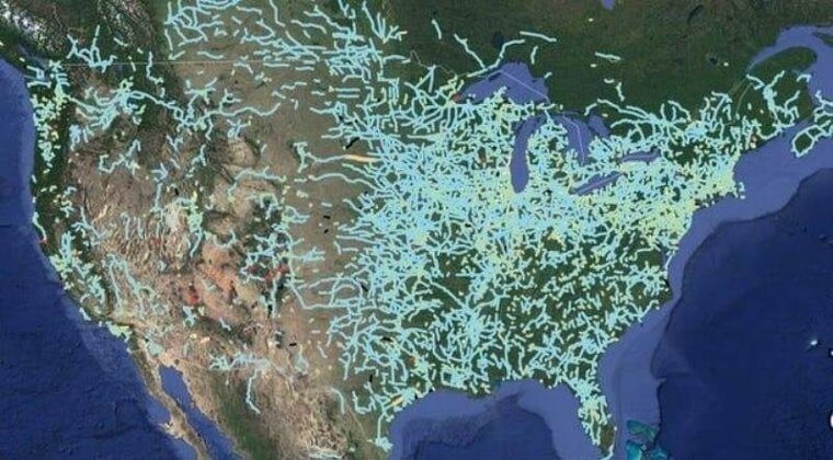
Railways To Nowhere

I was quite surprised by this.

During the Industrial Revolution in America, railroads were seen as the future of transportation and commerce. Companies raced to lay tracks, believing that every city, town, and settlement would soon be connected by rail. This led to a frenzy of railroad expansion, with investors pouring money into new ventures, often without fully considering the long-term feasibility or demand for some of these routes. Railroads were constructed to reach even the most remote areas, often in hopes that the arrival of rail service would spark economic growth in these regions.

However, by 1893, this speculative boom came crashing down during what became known as the Panic of 1893. This financial crisis was one of the most severe in U.S. history and marked a turning point for the railroad industry. The economy fell into a deep depression, leading to widespread bank failures, bankruptcies, and unemployment. Railroad companies, many of which were over-leveraged and dependent on continued investment and growth, faced severe financial difficulties. Numerous railroads went bankrupt, and construction projects were abandoned.

As a result, many of these incomplete railroads led to “nowhere,” cutting through landscapes without reaching their intended destinations or serving populations large enough to sustain them.

These ghost railroads, remnants of a once-ambitious vision of connectivity, are scattered across the country and someone put together this map.

Railroad To Nowhere

If you’re curious about how many USA’s fit into Australia or perhaps flamingo migration patterns, or want to know where Canadians live? The link is below.

https://news.moovitapp.com/en/show-world-really?ly=native_one&abtv=a

my favorite map?
if i’m not misunderstanding your question, this:

goth-map

You’ll need to re-post this in 6 months, because ”summer is coming” just doesn’t sound like the right reply right now. :hot_face:

Can I change my mind?

This map shows what is reportedly the longest train trip you can take on the planet.

My favorite RR map would be this one of the East Branch and Lincoln logging railroad in NH

The old roadbed are now hiking trails and I’ve been on all of them over the years. I have some spikes I found while backpacking there. I’ve always wanted to build this bridge on my RR, or even in a smaller scale. It’s full of backwoods charm, including the horse path bridge on the bottom.

image

1 Like

Folks;

While not published in 2024, I would have to say the map shown below is my favorite - partly for its family history.

In 1935 my uncle, Carl Gingrich, received a trip to Germany as a college graduation present. (He could speak fluent German, as his grandfather had immigrated from there, and only allowed German to be spoken at the supper table.) As part of the trip, he received the brochure below (printed in English). One side extols the centennial of Germany’s railway system, the other has a full map of said system. It is getting rather fragile, so I don’t open it too often, but it shows a glimpse or that country prior to WWII.


Regards, David Meashey

3 Likes

Honestly my favorite map is this one and it’s been my favorite for the last 30yrs!
What’s funny is all you need is a compass and a measuring device and it’s TRULY TO SCALE (taking advantage of CAPS LOCK whoever that is). 30yrs ago it took me places that never heard of the internet and today it takes me places that the internet cannot go!

Now with that said I’d like to give a “SHOUT OUT” to those Rhode Island guys!

1 Like

Let’s not forget those…

Nice map Rooster. I’m right under the seal.

1 Like

@Dave_Meashey (Dave) an unexpected cartographer obituary in today’s feed may be of interest.

Bill;

An interesting read. I had always thought the maps had been done by J. R. R. Tolkein, himself,

Best, David Meashey

My fave is this one from 1877, a birds eye view (aka panorama map) of Virginia City NV, with only the V&T RR stuff shown.

LOC has lots of these.

1 Like

The Ohio River and Western Railway was a result of this. 3 smaller rail lines merged to the O.R.&W.R. Their stable included 2 Baldwin locomotive Moguls along with others. Baldwin manufactured in Altoona and Philadelphia Pennsylvania. The Philly plant was moved to Eddystone Pa. for more room. I grew up right next store in Ridley Township.

The O.R.&W.R. was bought by the Mighty Pennsylvania R.R. just after the turn of last century. I started with HO trains and N gauge many years ago, but I also started buying LGB. Found out the only narrow gauge line that wore The Pensy logo was the O.R.&W.R.

Earlier start:

1 Like

Remember when transcontinental railways and trains running under the sea were unobtainable pipe dreams?

Imagine now World Peace…:crazy_face:

1 Like

Very cool! I had no idea that someone was raising money for this.

They have another version, and much of it indeed exists! I mean, El Paso to Paris, I’m on board!

But I suspect it’s that dashed part that will have issues.

:grinning_face_with_smiling_eyes:

1 Like

Funny thing—according to the site, people have been floating the idea of a rail link from Europe to North America since the 1860s. I think The Bering Strait tunnel wouldn’t even be the hardest part; it’s about the same length as some tunnels already built.

Apparently building across permafrost would be the real beast.

They probably should first talk to that guy in Paraguay about getting his railway to the El Paso terminus… but there’s apparently something called the Darién gap to contend with to his north.

i don’t know, what you are talking about.
the plans are completed, the obstacles were solved by localizating the used techniques.
the first part from the “Green Hell” to the foothills of the Andean mountains will use 4-4-0 steamers with three cars. (1 Pullman, 1 stockcar, 1 flatcar - first to third class)
the second (and longest) part, following the Andean foothills from Bolivia to Columbia made the project possible, thanks to the ingenious modernisation to replace the expensive steelrails by chiselled stone grooves. powered by PPP*
in Columbia there will be conventional steel track, driven by Diesel engines.
(thanks to the very low prices for used deep-fry oil from the local food industry)
even the problems of the formerly feared Darién gap found their solution:
for this part of the line, passengers are to be transferred from the Pullman train to a muletrain.
in panama, generally served by the good old 4-4-0 locos there is one shorter section where the passengers are transferred from Pullman to gondolas (moved by PRP**)
further north in middle America we can rely on reactivated revolutionary locos and additional flatcars for further revenue and the existing track.
for the last section of about half a mile to El Paso restringido the pullman passengers receive tourist visa, the other two classes are referred to swim training.

estimated duration of the journey: 8 to 10 weeks (one-way)

( PPP* = peasant pushing power
PRP** = peasant rowing power)

ps: southbound tickets at a 80% price reduction!

so, while we found solutions for our project, we don’t even dare to think abot the problems of permafrost railroading.

icicles spitting locomotives - shudder!
house training polar bears for drafting power - shudder!!
importing penguins as conductors - grumble
renting reindeers - purse-shock
toilets with defrosting devices - hurt

the only positve aspect, i could see, would be renting out peltcoats to third class passengers…

2 Likes

I should have known you’d have been working on this issue since emigrating, I’m onboard with everything but the polar bears training. :grinning:

Bering sea,

Guess none care about the tunnel bridge from Chili to Antarctica

Hollywood, I’m laughing because the other map I saw today was this one…IMG_1280